New Climate Engine Drought Reports Bring Drought Context to Management Decisions
Custom, repeatable drought summaries for resource managers across the conterminous United States

Read the full documentation for the new Drought Reports at the ClimateEngine.org support website.
Drought can rarely be defined by a single variable. Drought conditions may reflect low precipitation, unusually warm temperatures, high evaporative demand, reduced soil moisture, stressed vegetation, low reservoir levels or streamflow, or some combination of these factors. For managers and decision makers, it can be a challenge simply to access, let alone interpret, multiple lines of evidence to understand how drought conditions are impacting the resource they are interested in.
Climate Engine’s updated Drought Reports are designed to help make it easier to evaluate drought conditions using multiple drought indicators.
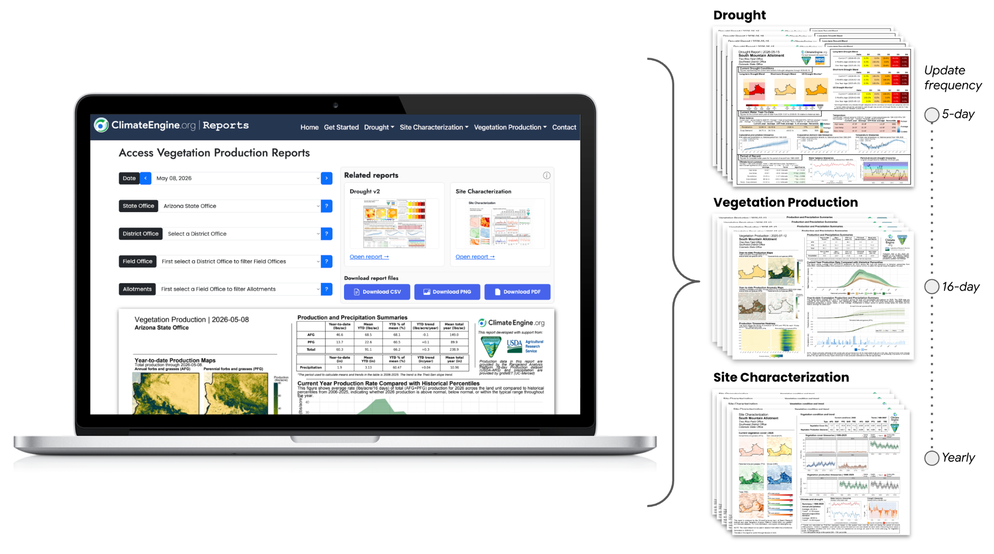
The new reports summarize current drought conditions, current water-year climate conditions, and longer-term drought and climate context for user-defined areas of interest. Reports can be produced for management units, planning areas, counties, states, watersheds, grazing allotments, field offices, conservation areas, or other boundaries where managers need a consistent and interpretable view of drought conditions.
For agencies and organizations working across many land units, these reports also create a repeatable way to compare conditions across geographies. Instead of manually producing maps, extracting time series, and compiling summary statistics for each location, Climate Engine can generate standardized reports that package key drought and climate indicators into a concise PDF and PNG report format and CSVs of tabular data for use in various processes.
This article introduces the updated Drought Reports, explains how they fit within the broader Climate Engine reporting framework, and highlights how our partnership with the Bureau of Land Management (BLM) is helping make pre-computed reports available for BLM land units across the conterminous United States.
Why Drought Reports?
Drought information must be timely, spatially relevant, and easy to interpret alongside management questions in order to be useful for informing drought response and planning.
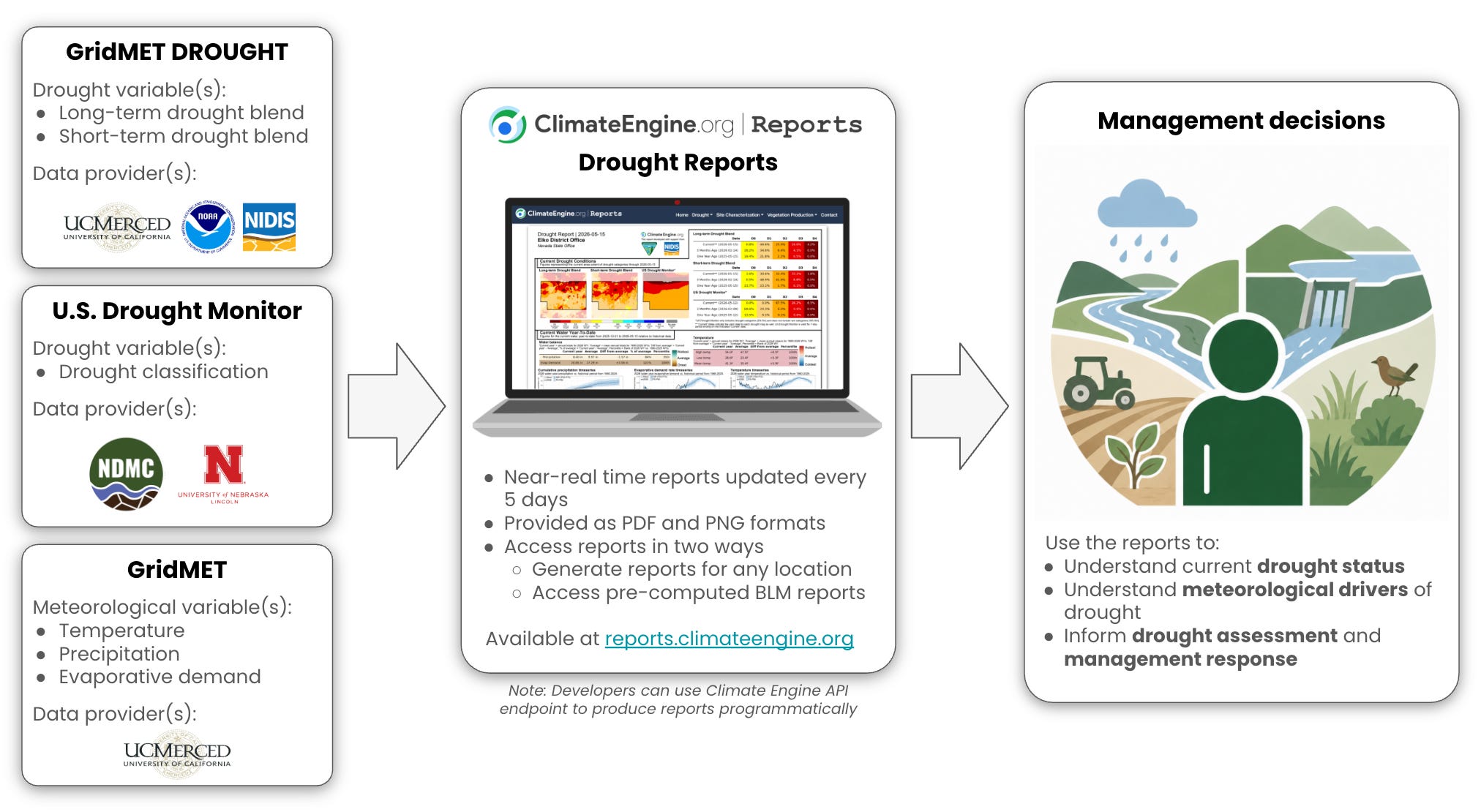
National-scale products such as the U.S. Drought Monitor provide a valuable common frame of reference for drought severity. Climate and hydrology datasets like gridMET provide additional detail on the conditions contributing to drought, including precipitation, temperature, and atmospheric demand for water. Gridded drought indicators from gridMET Drought can help distinguish shorter-term drought signals from longer-term moisture deficits.
Each of these indicators of drought are useful, but they are not interchangeable and they do not always agree. A single drought map may show broad drought status, while a water-year precipitation time series may show whether current drought conditions are the result of a persistent seasonal deficit or a recent dry spell. Evaporative demand can help explain why drought impacts may intensify even when precipitation is near average. Additionally, drought indicators representing different time periods or different resource impacts may conflict with one another, underscoring the importance of managers’ role in interpreting these signals to address resource issues.
The Climate Engine Drought Reports bring these pieces together in a one-page structured, consistent summary that can be used to understand different dimensions of drought for a given location. They are intended to support drought evaluation, situational awareness, planning discussions, and communication among managers, analysts, partners, and local experts.
What the Updated Reports Include
The updated Drought Reports are organized around three themes:
Current drought conditions
Current water year-to-date climate conditions
Period of record drought/climate conditions
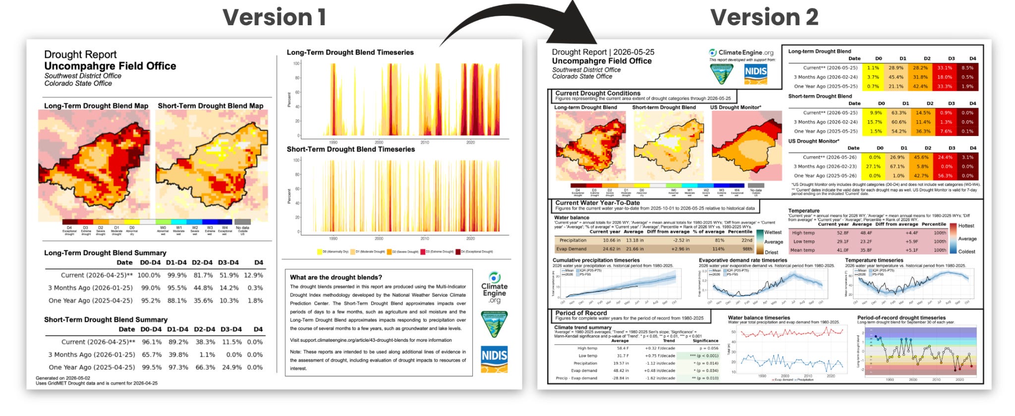
To answer these questions, the reports combine multiple datasets and indicators, including the U.S. Drought Monitor, short-term and long-term drought blends derived from gridMET Drought, and gridMET climate variables such as precipitation, evaporative demand, and temperature.
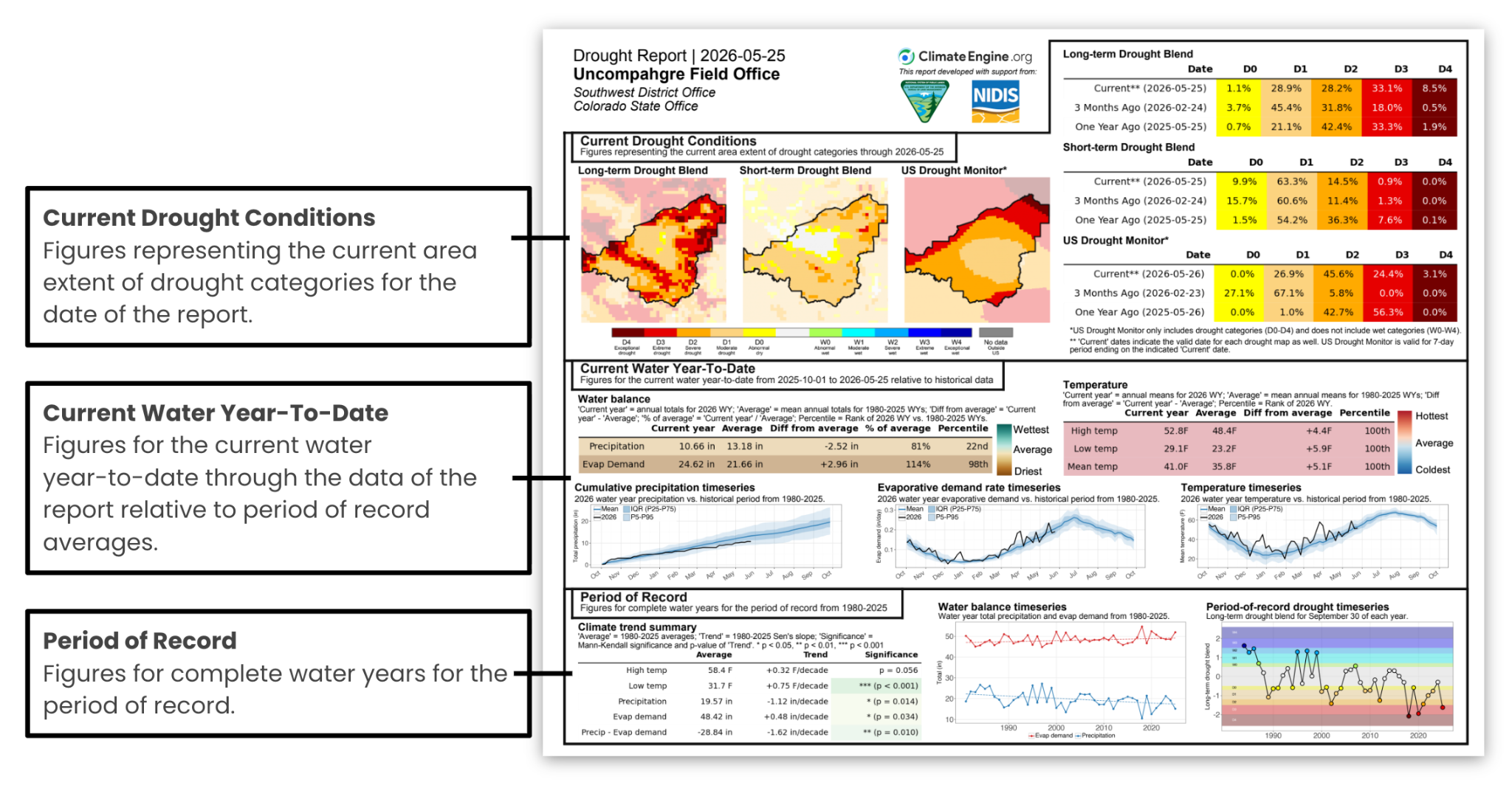
Current Drought Conditions
The first section focuses on current drought status. It includes the U.S. Drought Monitor alongside short-term and long-term drought blend maps calculated using gridMET Drought.
Reviewing a combination of drought metrics can be important because drought impacts occur as a response to meteorological drivers over multiple time scales. Short-term indicators can be more responsive to recent precipitation deficits, high temperatures, or rapid changes in evaporative demand and can lead to rapid curing of fuels and stress to vegetation. Longer-term indicators are more relevant for slower-moving impacts to water supply, groundwater, reservoirs, vegetation condition and mortality, and other resource concerns.
Where these indicators agree, managers can have confidence that drought signals are consistent. Where they differ, the report helps identify areas where additional interpretation, local knowledge, field observations, or supporting data may be needed.
Current Water-Year Conditions
The second section summarizes the current water year-to-date. It includes summary tables and time series for precipitation, evaporative demand, and temperature, helping managers identify the timing of precipitation events, dry periods, warm periods, and pressure from evaporative demand.
Distinguishing between drivers of drought can be important. For example, two areas may have similar drought classifications but very different recent climate and weather conditions. One may have experienced a long precipitation deficit. Another may have received near-average precipitation but faced unusually high temperatures and evaporative demand. Depending upon the resource under consideration — e.g. forage, water availability, vegetation stress, ecological condition, wildfire risk, or operational flexibility — the sequence and trajectory of the drivers contributing to the drought classification can be very important.
Period-of-Record Context
The third section places current conditions in a longer-term context. It summarizes historical water-year precipitation, evaporative demand, and temperature patterns from 1980 through the previous complete water year, along with trend statistics and time series that show how these variables have changed over time.
This context helps managers understand the long-term trajectory of the site, which may be contributing to the long-term drought signal or shifts in baselines. For example, this section can help show whether current drought concerns are occurring against a backdrop of long-term warming, increasing evaporative demand, declining precipitation, or recurring drought conditions.
It is important to keep in mind that these reports are not forecasts, and they do not replace local expertise or field-based assessment. Additionally, just because a trend has occurred in the historic period from 1980-present, it does not mean it will continue into the future.
Using Drought Reports with Site Characterization and Vegetation Production Reports
The Drought Reports are designed to be used alongside other Climate Engine reports, specifically the Site Characterization and Vegetation Production reports. Additionally, new reports are in development that will provide additional information alongside the Drought Reports.
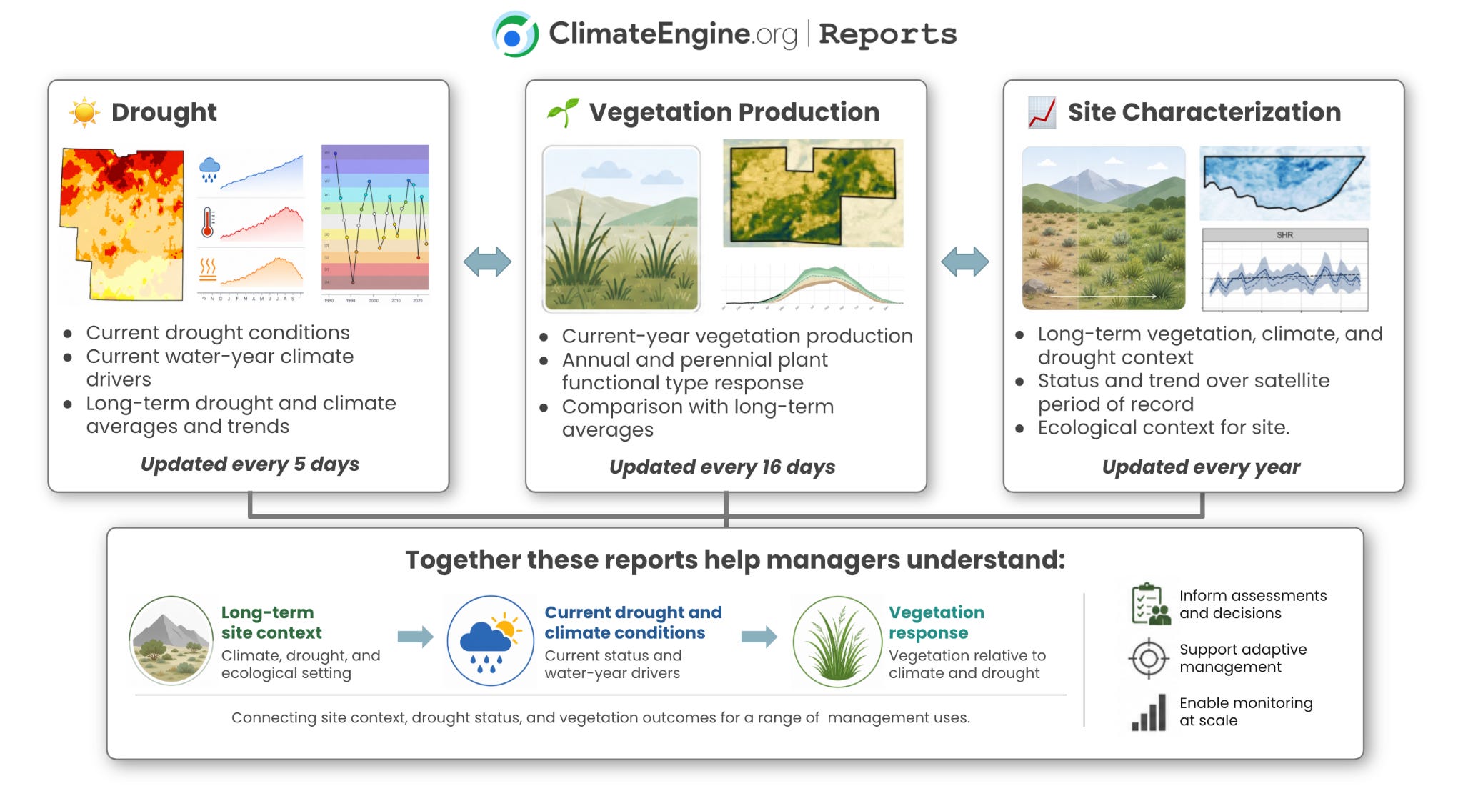
The Site Characterization Reports provide a longer-term view of a management unit. They describe status and trend in vegetation, climate, and drought over a roughly 40-year period of record. These reports are useful for understanding the broader ecological and climatic setting of a site before interpreting current-year conditions. These reports are updated yearly. Find more information about the Site Characterization Reports in the Climate Engine documentation.
The Vegetation Production Reports focus more directly on current-year vegetation production. They show current year production in the context of long-term averages and trends, helping managers understand whether annual and perennial herbaceous production is above, below, or near expected levels for a given area. These reports are updated every 16 days. Find more information about the Vegetation Production Reports in the Climate Engine documentation.
Used together, the reports support a more complete interpretation:
Drought Reports show current drought status, current water-year climate drivers, and longer-term drought context.
Site Characterization Reports describe the long-term vegetation, climate, and drought setting of a site.
Vegetation Production Reports show how current-year vegetation production compares with long-term patterns.
This combination is especially useful when managers need to understand how vegetation is responding to ongoing drought. For example, a Drought Report may show below-average precipitation or unusually high evaporative demand, while a Vegetation Production Report may show whether perennial and annual herbaceous production has declined in response. Together, these reports help connect climate conditions, drought indicators, and vegetation outcomes in a way that is more useful than any single report on its own.
Custom Reports for Management-Relevant Areas
A central goal of Climate Engine Reports is to make large climate and remote sensing datasets easier to access and use for real-world decision making.
Managers rarely make decisions for a single grid cell. They make decisions for management areas or administrative units such as allotments, counties, watersheds, park units, refuges, districts, field offices, planning boundaries, restoration areas, or landscape partnership boundaries. Custom Drought Reports allow users to summarize drought conditions for any type of geography.
For a custom area of interest, Climate Engine can generate a report that helps answer questions such as:
What percent of this area is currently in each drought class?
Are short-term and long-term drought indicators in agreement or conflicting?
Has precipitation been below average for the current water year?
Has evaporative demand been above average for the current water year?
How does the current year compare with the period of record (1980-present)?
Are longer-term trends suggesting increasing drying pressure, warming, or recurring drought?
Because the reports are standardized, they can also be rerun as new data become available. This allows managers to track changing conditions over time without rebuilding an analysis from scratch.
Generate custom Drought Reports here.
Designed for Screening, Planning, and Communication
The Drought Reports are intended to support several common management needs.
For situational awareness, they provide a current summary of drought status and the water-year conditions contributing to it.
For planning and response, they help identify whether drought concerns appear to be short-term, long-term, precipitation-driven, temperature-driven, or intensified by high evaporative demand.
For communication, they provide a consistent visual and quantitative summary that can be shared among managers, analysts, leadership, partners, and stakeholders.
These uses are most powerful when the reports are interpreted alongside other information. For example, field observations, resource monitoring data, streamflow and groundwater data, snowpack information, local water-supply conditions, and knowledge from managers and communities remain essential.
Partnership with BLM: Pre-Computed Reports for Public Land Units
Climate Engine has partnered with the Bureau of Land Management (BLM) to make drought information more accessible and actionable for public land management.
Through this partnership, BLM leadership from Aquatics, Rangeland Management, Assessment, Inventory, and Monitoring AIM) has contributed to the development of the drought reports to support agency-wide drought and water availability decisions. To support this work, Climate Engine pre-computes Drought Reports for BLM land units, including grazing allotments, field offices, district offices, and state offices every five days as new data become available. These reports are available through the Climate Engine Reports website (reports.climateengine.org/droughtv2), allowing BLM staff and the public to rapidly access consistent, regularly updated drought summaries without having to generate each report manually.
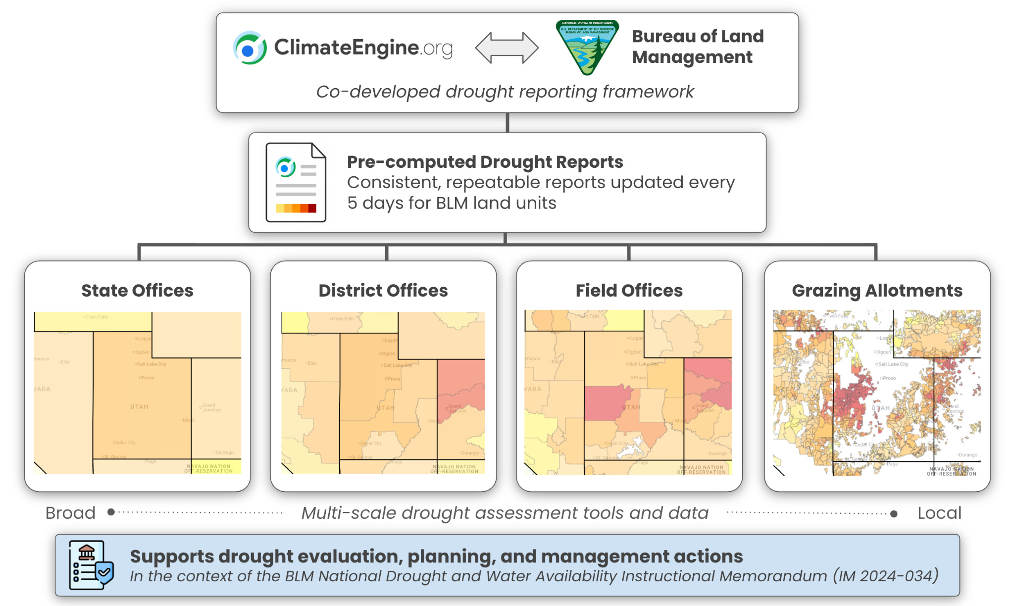
This pre-computed reporting model is especially useful for large organizations. BLM manages lands across diverse climates, ecosystems, and resource programs. Drought conditions can vary substantially across individual field offices and broader administrative units and managers often need to understand both local conditions and broader regional patterns.
By producing reports across BLM land units, Climate Engine helps lower the barrier to using climate and drought data in planning, monitoring, and response activities. Staff can begin with a ready-made report for their area, then combine that information with local knowledge, field observations, water-supply information, vegetation monitoring, and other relevant sources.
Alignment with BLM Drought and Water Availability Policy
The development of the updated Drought Reports has been supported by the Bureau of Land Management and aligns with the agency’s National Drought and Water Availability Instruction Memorandum.
That policy emphasizes the importance of considering drought conditions and water availability in public land planning and decision making. It also recognizes the need to compare multiple drought indicators at relevant landscape scales because no single indicator can fully represent drought conditions across all geographies, resources, and management contexts. The Climate Engine Drought Reports were designed to streamline access and synthesis of these data.
We are grateful to BLM leadership at Headquarters and the National Operations Center for their contributions to the conception and development of these reports and for helping ensure that the reporting framework is relevant to the decisions managers face on the ground.
Accessing the Reports
All of the Climate Engine reports can be accessed at reports.climateengine.org. For all of the tools and information related to the Drought Reports, see below:
🛠️Tool to generate Drought Reports for custom areas of interest: reports.climateengine.org/droughtv2
🏞️Precomputed Drought Reports for BLM land units: reports.climateengine.org/droughtv2
🧑💻Climate Engine API endpoints for programmatically producing Drought Reports: https://climateengine.org/apis/reportsEndpoints/
📄Full documentation: https://climateengine.org/reports/using-droughtv2/